Indonesia Volcano Hikes Basics With Trail Conditions, Equipment Tips, and Adventure Insights
Indonesia is an archipelago with thousands of islands, a varied landscape, and numerous active and dormant volcanoes. Its position along the Pacific Ring of Fire contributes to frequent volcanic activity and the formation of mountains, craters, volcanic lakes, and distinctive geological features.
These landscapes attract hikers interested in nature, physical activity, geology, and outdoor exploration.
Indonesia volcano hikes range from relatively accessible mountain walks to demanding climbs involving steep slopes, loose volcanic gravel, exposed ridges, and early-morning starts. Popular destinations include Mount Bromo, Mount Rinjani, Mount Ijen, and Mount Semeru. Each mountain has different terrain, elevation, environmental conditions, and access requirements.
Volcano hiking differs from ordinary hill walking because volcanic environments can change quickly. Loose rocks, volcanic gases, sudden weather changes, and restrictions around active craters can influence whether a trail is suitable for visitors.
Popular Volcano Hiking Destinations
Mount Bromo in East Java is known for its broad volcanic landscape, sandy caldera, and surrounding viewpoints. Visitors can experience parts of the area through relatively short walks, although access near the crater depends on current conditions and official restrictions.
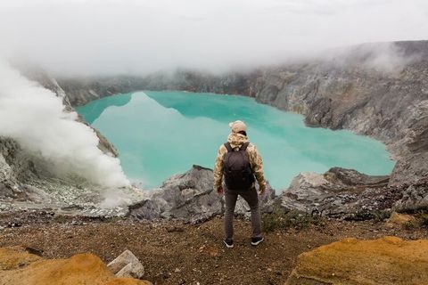
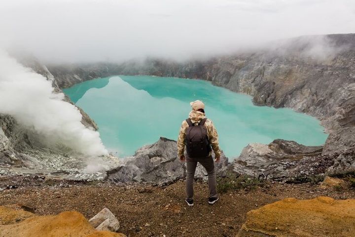
Mount Rinjani on Lombok is associated with longer trekking routes, substantial elevation changes, and views of Segara Anak, a crater lake within the volcanic complex. Mount Ijen, also in East Java, attracts visitors interested in its crater lake and distinctive volcanic landscape. Mount Semeru is a high volcanic mountain that requires particular attention to volcanic activity and climbing restrictions.
These destinations differ considerably in difficulty. Route length, elevation gain, overnight arrangements, weather exposure, and current volcanic conditions should all be considered before selecting a hike.
Importance
Why Volcano Hiking Matters
Indonesia volcano hikes support outdoor recreation, nature education, and appreciation of the country's geological diversity. Hiking also gives visitors an opportunity to understand how volcanic activity shapes landscapes, influences soil formation, and creates habitats for different plant and animal species.
These trips can also support communities around mountain destinations through spending on accommodation, transport, food, equipment, and local guiding. However, tourism in volcanic environments requires careful management because heavy visitor traffic can damage vegetation, increase litter, and place pressure on local infrastructure.
Safety is another important consideration. A route that appears manageable on a map may become challenging because of altitude, slippery surfaces, poor visibility, or volcanic hazards. Understanding these factors helps hikers prepare realistically and recognize when conditions are unsuitable.
Who Should Consider Trail Difficulty?
Volcano hiking attracts beginners, experienced trekkers, families, photographers, and international adventure travelers. However, the same route may feel very different to different people depending on their fitness, experience, and tolerance for altitude or cold temperatures.
Beginners may prefer shorter walks around established viewpoints rather than long summit routes. More demanding treks may involve several hours of climbing, overnight camping, limited access to drinking water, and difficult descents over loose volcanic material.
Before choosing a destination, hikers should assess:
Physical fitness and previous hiking experience.
Total walking distance and elevation gain.
Expected temperature, rainfall, wind, and visibility.
Availability of drinking water, toilets, shelters, and emergency assistance.
Current volcanic activity and permitted trail boundaries.
Recent Updates
Volcano Hiking Trends and Conditions
During 2024–2026, volcano tourism continues to require attention to changing volcanic activity, visitor management, and environmental protection. Conditions vary by mountain, and an area that is accessible during one period may be restricted when volcanic activity increases or weather creates additional hazards.
Mountains such as Mount Bromo and Mount Ijen remain recognized destinations for volcanic landscapes, while longer routes on Mount Rinjani require more substantial preparation. Access rules, trekking arrangements, and trail availability can change in response to environmental conditions and management decisions.
Digital maps, mobile navigation tools, weather forecasts, and official volcanic monitoring information have become useful parts of trip planning. Nevertheless, mobile coverage can be unreliable in mountainous terrain, and digital maps may not reflect temporary closures or newly established exclusion zones.
How Weather and Volcanic Activity Affect Routes
Weather in Indonesia's mountains can differ from conditions in nearby towns and coastal areas. Rain can make paths slippery, increase erosion, and reduce visibility, while strong winds and low temperatures can make exposed sections uncomfortable or hazardous.
Volcanic hazards require separate consideration from ordinary hiking risks. Gas emissions, ash, crater instability, and eruptions can create dangerous conditions even when the surrounding landscape appears calm. Visitors should follow official restrictions rather than relying on photographs, social media reports, or conditions observed from a distance.
The following table provides a general comparison of several hiking destinations. Difficulty descriptions are indicative rather than official classifications, and access depends on current conditions.
Volcano | Main attraction | General hiking profile | Key consideration |
|---|---|---|---|
Mount Bromo | Caldera, volcanic sand, viewpoints | Shorter walks and viewpoint routes | Crater access restrictions |
Mount Ijen | Crater lake and volcanic scenery | Steep ascent and descent | Volcanic gases and exclusion zones |
Mount Rinjani | Crater lake and mountain panoramas | Demanding, often multi-day trekking | Elevation, endurance, and weather |
Mount Semeru | High mountain terrain and volcanic scenery | Strenuous high-altitude trekking | Strict activity-related closures |
Preparing for Changing Trail Conditions
Preparation should include checking the latest official announcements before departure and again shortly before entering the mountain area. Hikers should confirm whether the intended route is open, whether permits or designated guides are required, and whether any weather or volcanic warnings affect the itinerary.
A flexible schedule is useful because a planned summit attempt may need to be postponed or abandoned. Safe hiking depends on responding to actual conditions rather than treating reaching the summit as the main objective.
Laws or Policies
National Park Rules and Entry Requirements
Indonesia manages many mountain destinations through national parks, conservation areas, and local authorities. Rules may cover visitor registration, trekking permits, designated trails, group arrangements, guide requirements, camping locations, waste management, and access to sensitive areas.
Mount Rinjani lies within Mount Rinjani National Park, while Mount Semeru is within Bromo Tengger Semeru National Park. Visitors should check the relevant park authority's current procedures because registration systems, entry arrangements, and permitted routes may change.
Mount Bromo's protected landscape and Mount Ijen's volcanic environment are also subject to access management. Visitors must respect posted boundaries and instructions from authorized personnel, particularly when access to crater areas is restricted.
Volcanic Alerts and Safety Restrictions
Indonesia's Center for Volcanology and Geological Hazard Mitigation, commonly known as PVMBG, monitors volcanic activity and communicates information about volcanic alert levels and hazards. These updates help authorities determine whether access restrictions or exclusion zones are necessary.
Hikers should distinguish between a mountain's general tourist status and its current operational conditions. A destination may remain open for some activities while specific trails, crater areas, or summit routes are closed.
Important rules and precautions include:
Follow official volcanic alert announcements and designated exclusion zones.
Register through the applicable park or authorized trekking system.
Carry required identification, permits, and other applicable documents.
Follow instructions from park staff, rangers, and authorized guides.
Avoid littering, damaging vegetation, disturbing wildlife, or leaving marked trails.
Do not enter restricted areas to obtain photographs or reach a viewpoint.
Regulations and entry arrangements differ among destinations. General hiking information should not be treated as confirmation that a particular route is currently open.
Tools and Resources
Navigation and Weather Planning
Several types of tools can help hikers evaluate trail conditions and prepare their equipment. Each has a different purpose, and no single tool provides a complete assessment of mountain safety.
Digital trail maps: Offline mapping applications can help with route orientation, distance estimates, and navigation when mobile connectivity is limited. Hikers should download relevant maps beforehand and avoid treating user-generated trail information as confirmation of official access.
Weather forecasting tools: Mountain-specific forecasts help users assess rainfall, wind, temperature, and visibility. Conditions at higher elevations may differ from forecasts for nearby towns, so several relevant locations and elevation levels should be considered when available.
Official volcanic monitoring information: PVMBG announcements and information from the responsible national park provide important details about volcanic activity, hazard zones, and restrictions. These sources should take priority over unofficial travel updates.
Equipment checklists: A written checklist helps ensure that essential items are packed before departure. It can also be used to review equipment after each hike and identify missing or damaged items.
Essential Equipment for Volcano Hiking
The equipment required depends on the route, season, duration, and altitude. A short walk around an established viewpoint may require less equipment than a multi-day mountain trek.
Footwear: Hiking shoes or boots with suitable traction for loose gravel and uneven ground.
Clothing: Breathable layers, warm outerwear, and rain protection appropriate to the forecast.
Lighting: A reliable headlamp for early starts or low-light conditions.
Hydration: Sufficient drinking water and a practical way to carry it.
Navigation: An offline map, a charged phone, and a backup navigation method suited to the route.
Emergency supplies: A first-aid kit, emergency whistle, and appropriate personal medication.
Sun protection: Sunglasses, sunscreen, and a hat for exposed terrain.
Food: Suitable snacks and meals for the expected duration and physical demands.
For longer routes, additional equipment may include a suitable backpack, sleeping arrangements, trekking poles, and emergency shelter. Requirements should be checked with the responsible park or trekking organizer before departure.
FAQs
What Are the Main Indonesia Volcano Hikes for Beginners?
Mount Bromo is often considered for shorter walks and volcanic viewpoints, depending on current access arrangements. Beginners should choose an appropriate route based on fitness, weather, and official restrictions rather than assuming every section is easy.
What Equipment Is Needed for Indonesia Volcano Hikes?
Essential equipment generally includes suitable hiking footwear, layered clothing, rain protection, drinking water, a headlamp, navigation tools, sun protection, and basic first-aid supplies. Longer treks may require camping equipment and additional emergency supplies.
Are Indonesia's Volcano Hiking Trails Always Open?
No. Trails may close because of volcanic activity, weather, environmental protection measures, or park management decisions. Current official announcements should be checked before entering a mountain area.
How Difficult Is Mount Rinjani Trekking?
Mount Rinjani trekking is generally demanding because of its elevation, steep terrain, and long walking distances. Some itineraries require multiple days and overnight arrangements, so physical preparation and appropriate equipment are important.
How Can Hikers Check Indonesian Volcano Safety Conditions?
Hikers can consult PVMBG volcanic monitoring announcements, the responsible national park authority, local ranger instructions, and relevant weather forecasts. Official restrictions should be followed even when conditions appear suitable from a viewpoint.
Conclusion
Indonesia volcano hikes provide opportunities to explore volcanic landscapes, crater lakes, mountain trails, and distinctive natural environments. Route difficulty, equipment requirements, and access rules vary substantially among destinations. Weather conditions and volcanic activity must be assessed using current official information rather than assumptions based on previous visits. Careful preparation and respect for protected areas are important elements of responsible mountain travel.