Explore Volcano Trekking Adventures With Trail Planning, Safety, and Travel Advice
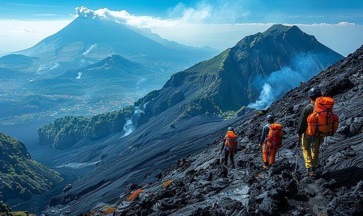
Volcano trekking adventures involve hiking across volcanic landscapes, including established mountain trails, crater viewpoints, lava fields, volcanic ridges, forests, and high-altitude terrain.
These journeys combine outdoor recreation with geological exploration and can range from relatively short walks to demanding multi-day mountain routes.
Volcanic landscapes are created through geological activity beneath Earth's surface. Eruptions, lava flows, ash deposits, rock formation, erosion, and vegetation growth can gradually create distinctive terrain. As a result, volcano trekking can provide an opportunity to observe geological features that are different from ordinary mountain environments.
A volcano trek may take place on an active, dormant, or extinct volcanic mountain. However, the classification of a volcano does not by itself determine whether a trail is safe. Volcanic areas can contain unstable ground, sudden weather changes, falling rocks, volcanic gases, hot surfaces, loose ash, steep slopes, and other hazards.
Trail planning is therefore an important part of the experience. Travelers generally need to understand the route, elevation, distance, terrain, weather, access restrictions, emergency arrangements, and local instructions before beginning a trek.
Types of Volcano Trekking Routes
Volcano trekking routes vary considerably. A lower-elevation trail may pass through forest and volcanic rock before reaching a viewpoint, while a higher route can involve steep slopes, loose volcanic material, cold temperatures, and reduced oxygen levels.
Common route categories include:
Crater viewpoint trails
Summit trekking routes
Lava-field walks
Volcanic ridge hikes
Forest-to-summit trails
Multi-day volcanic mountain routes
Geothermal landscape walks
Caldera and crater-rim routes
Some routes have clearly established paths and marked sections. Others may involve rough terrain where navigation skills and local knowledge are more important.
Understanding Volcanic Terrain
Volcanic terrain can change considerably over short distances. Hardened lava may provide firm surfaces in one section, while ash, pumice, gravel, or loose volcanic rock can make another section unstable.
Crater areas require particular awareness because volcanic activity can occur even when a mountain appears quiet. Travelers should follow current access restrictions and remain within designated areas rather than approaching restricted zones.
Importance
Volcano trekking matters because it combines physical activity, travel, geology, nature, and cultural exploration. Volcanic mountains are found in many parts of the world, and their landscapes can support forests, wildlife, agricultural communities, and culturally significant locations.
The activity also requires more planning than an ordinary recreational walk. Altitude, terrain, weather, volcanic conditions, and access rules can all change the difficulty and risk profile of a route.
Who Participates in Volcano Trekking?
Volcano trekking attracts a broad range of outdoor travelers. Some participants choose short trails with moderate elevation, while experienced hikers may select longer routes involving substantial elevation gain.
The physical demands can vary according to:
Trail distance
Elevation gain
Surface conditions
Weather
Temperature
Backpack weight
Route duration
Available facilities
People with limited hiking experience may find steep volcanic terrain more demanding than a similar-distance trail on flatter ground. Fitness requirements should therefore be considered alongside distance.
Trail Planning
Trail planning begins with identifying the exact route and checking current access information. A map should show the trailhead, elevation profile, route length, expected hiking time, water points, shelters, emergency locations, and possible exit routes where applicable.
Weather should be checked close to departure because mountain conditions can change rapidly. Rain can make volcanic soil slippery, while strong winds, snow, heat, or cloud can reduce visibility.
A basic planning checklist can include:
Confirm trail status and access restrictions
Review the elevation profile
Check weather and volcanic activity information
Estimate walking time and daylight requirements
Identify water and rest locations
Prepare navigation equipment
Tell another person about the planned route
Check transportation arrangements
Carry appropriate clothing and emergency supplies
Physical Preparation
Volcano trekking can involve prolonged climbing and descending. Even a relatively short route may become physically demanding when elevation gain, loose surfaces, or high altitude are involved.
Preparation can include regular walking, stair climbing, hill training, balance exercises, and carrying a gradually increased backpack load. The appropriate preparation depends on the route and the participant's circumstances.
Recent Updates
From 2024 through 2026, volcano trekking has continued to develop alongside broader interest in outdoor travel, nature-based tourism, digital navigation, and real-time hazard information. Many travelers now use mobile mapping, weather applications, satellite positioning, and official hazard information when planning mountain activities.
Digital Trail Planning
Smartphone mapping applications can provide route information, elevation profiles, navigation data, and offline maps. GPS devices can provide another navigation option where mobile coverage is limited.
Digital tools are useful but should not always be treated as the only navigation method. Batteries can run out, signals can become unreliable, and routes may change because of weather, landslides, volcanic activity, or maintenance.
Volcanic Monitoring
Volcano monitoring has become increasingly important for outdoor travel in volcanic regions. Monitoring agencies may track seismic activity, volcanic gases, ground deformation, thermal changes, ash emissions, and other indicators.
Travelers should distinguish between ordinary weather information and volcanic hazard information. A clear weather forecast does not mean that a volcanic trail is open or suitable for travel.
Responsible Nature Travel
Volcano trekking has also become connected with environmental awareness. High visitor numbers can cause trail erosion, vegetation damage, litter, and disturbance to wildlife or culturally significant areas.
Responsible trekking practices include staying on designated paths, carrying waste out when required, avoiding removal of rocks or natural materials, respecting wildlife, and following local access restrictions.
Changing Trail Conditions
Volcanic trails can change after heavy rainfall, earthquakes, landslides, eruptions, rockfalls, or other geological events. A route that was accessible during one season may later be closed or altered.
This makes current trail information particularly important. Printed guidebooks and older travel descriptions can provide background information, but they may not reflect recent changes in access or hazards.
Laws or Policies
Volcano trekking is shaped by national and local rules covering protected areas, tourism access, environmental protection, emergency management, land ownership, wildlife conservation, and volcanic hazard zones. Requirements vary significantly between countries and individual volcanoes.
Protected Area Rules
Many volcanic mountains are located within national parks, nature reserves, protected landscapes, or other managed areas. Visitors may be required to remain on designated trails and follow restrictions concerning camping, fires, waste, wildlife, and vehicle access.
Some areas also have rules concerning group sizes, operating hours, seasonal closures, or access permits. These requirements should be checked through the relevant local authority before a trek.
Volcanic Hazard Restrictions
Authorities can establish exclusion zones around active volcanic areas. These zones may change according to volcanic monitoring information.
A restricted area can remain closed even when visual conditions appear normal. Travelers should follow official instructions rather than entering a closed area to reach a particular viewpoint or route.
Environmental Protection
Volcanic landscapes can contain fragile ecosystems and culturally significant sites. Environmental rules may restrict removal of rocks, plants, minerals, archaeological materials, or other natural objects.
Local cultural rules can also apply where volcanic mountains have religious or historical importance. Appropriate clothing, behavior, photography restrictions, and access limitations may be part of local requirements.
Emergency and Travel Requirements
Mountain rescue systems differ by destination. Some areas have established rescue infrastructure, while remote routes may require travelers to carry additional navigation and emergency equipment.
Travelers should understand local emergency procedures and know how to communicate their location. Depending on the destination, mobile coverage may be limited or unavailable.
Tools and Resources
Several tools can support volcano trekking preparation. Digital maps can provide route lines, elevation information, and offline navigation. Weather applications can help travelers monitor temperature, precipitation, wind, and visibility.
Official volcanic monitoring platforms are particularly relevant for active volcanic regions. Park authorities and local tourism offices may provide trail closures, access notices, maps, transportation information, and environmental guidance.
Useful planning resources include:
Offline trail maps
GPS navigation devices
Elevation calculators
Weather applications
Volcanic activity reports
Park maps
Trail condition notices
Emergency contact lists
Hiking time calculators
Packing checklists
Satellite communication devices
Digital route planners
A basic comparison of route characteristics can help travelers understand how different trekking environments may vary:
| Route Type | Common Terrain | Main Planning Factor |
|---|---|---|
| Crater Viewpoint | Marked paths and volcanic slopes | Access restrictions |
| Summit Route | Steep and elevated terrain | Fitness and altitude |
| Lava Field | Uneven volcanic rock | Footing and navigation |
| Forest Volcano Trail | Vegetation and changing slopes | Weather and route marking |
| Caldera Rim | Exposed ridges and slopes | Wind and visibility |
| Multi-Day Route | Varied terrain | Food, water, shelter, and navigation |
Essential Trekking Equipment
Equipment should reflect the route, climate, altitude, and expected conditions. Common items can include sturdy hiking footwear, layered clothing, rain protection, sun protection, navigation equipment, sufficient water, food, a first-aid kit, and a headlamp.
For remote or high-altitude routes, additional equipment may be appropriate. Emergency communication devices can be particularly relevant where mobile networks are unreliable.
Equipment should also be checked before departure. Batteries, footwear, clothing, navigation devices, and weather protection can all affect preparedness.
FAQs
What is volcano trekking?
Volcano trekking is hiking across volcanic landscapes such as crater rims, lava fields, volcanic slopes, forests, calderas, and summit trails. Routes range from relatively short walks to demanding mountain expeditions.
How should I plan a volcano trekking trail?
Review the current trail status, elevation profile, weather, volcanic activity information, route length, daylight, water availability, and emergency arrangements. Carry navigation equipment and understand any access restrictions before starting.
Is volcano trekking dangerous?
Volcanic and mountain environments can involve hazards such as unstable ground, rockfall, steep slopes, extreme weather, volcanic gases, high altitude, and changing trail conditions. The level of risk depends on the specific volcano, current conditions, route, and preparation.
What should I pack for volcano trekking adventures?
Common equipment includes suitable hiking footwear, layered clothing, rain protection, water, food, navigation equipment, sun protection, a headlamp, and a first-aid kit. Remote or high-altitude routes may require additional equipment.
How do volcanic activity updates affect trekking?
Volcanic monitoring information can influence trail access and exclusion zones. A route may be closed or modified when monitoring indicates increased activity, so current official information is important before and during a planned trek.
Conclusion
Volcano trekking adventures combine hiking, geological exploration, nature, and travel across distinctive volcanic landscapes. Effective trail planning requires attention to terrain, elevation, weather, volcanic activity, access restrictions, equipment, and emergency arrangements. Digital maps and monitoring tools can support preparation, while official local information remains important for current trail conditions. Volcanic areas may also have environmental and cultural rules that travelers need to respect.