Guide to Drone Surveying: Explore the Future of Construction Site Intelligence
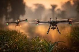
Drone surveying involves using unmanned aerial vehicles (UAVs) equipped with cameras, LiDAR sensors, GPS systems and photogrammetry software to capture aerial data of construction sites, terrain and infrastructure. The resulting information includes high-resolution 2D maps, 3D models, volume calculations and progress footage.
In construction, traditional site surveys rely on manual measurements and heavy equipment, which can be time-consuming and labor-intensive. Drone surveying offers a modern alternative—providing faster, safer, and more detailed site analysis from the air.
Importance
Drone surveying is transforming how construction projects are planned, managed, and executed.
Key reasons it matters today:
-
Efficiency: Drones collect precise topographic data in a fraction of the time.
-
Safety: They reduce human exposure to hazardous conditions and difficult terrain.
-
Accuracy: Aerial imaging and LiDAR sensors deliver centimeter-level precision.
-
Documentation: Frequent drone surveys enable visual progress tracking and compliance reports.
-
Cost management: Early error detection minimizes rework and delays.
As global infrastructure development expands, drone technology ensures that projects stay on schedule and meet the highest safety and quality standards.
Recent Updates
Between 2023 and 2025, drone surveying saw rapid technological evolution and industry-wide adoption.
| Year | Trend | Description |
|---|---|---|
| 2023 | LiDAR integration | Drones captured detailed terrain data even in dense or shaded areas. |
| 2024 | AI-driven data analytics | Automation identified deviations, volumes, and potential risks faster than manual reviews. |
| 2025 | Real-time monitoring | Drones enabled live site tracking, digital twins, and integrated BIM workflows. |
By 2025, drones have become standard tools across infrastructure, mining, and construction sectors. Advanced automation allows teams to schedule repeat flights and automatically compare data across project phases.
Laws or Policies
Drone surveying operates within regulated frameworks designed to protect safety, privacy, and data integrity.
Main regulatory areas include:
-
Airspace permissions: Operators often need flight authorization and must comply with visual-line-of-sight or specific airspace rules.
-
Data privacy: Aerial imaging regulations govern how personal or property data is captured and stored.
-
Survey accuracy standards: Professional standards define acceptable tolerances for mapping and modeling.
-
Operator training: Certified pilots are required to ensure safe handling of UAV equipment.
-
Environmental compliance: Drones help reduce the need for heavy vehicle access, supporting sustainability goals.
Compliance ensures credibility and fosters trust in drone-based surveying results across industries.
Tools and Resources
Drone surveying depends on specialized hardware and software for optimal performance and accuracy.
Essential Tools:
-
Survey Drones: Equipped with LiDAR, RTK GPS, or high-resolution cameras.
-
Photogrammetry Software: Converts aerial images into detailed 2D and 3D maps.
-
Data Management Platforms: Store, compare, and visualize project progress.
-
BIM Integration Tools: Align aerial data with architectural and engineering models.
-
Analytics Dashboards: Automate volume calculations, surface modeling, and inspection reports.
Helpful Resources and Best Practices:
-
Pilot certification programs for UAV operators.
-
Standardized templates for flight planning and reporting.
-
Quality assurance checklists for aerial data validation.
-
Training materials on LiDAR, 3D modeling, and data processing.
Quick Adoption Checklist:
-
Define survey goals and required accuracy.
-
Select the right sensor and mapping technology.
-
Establish survey frequency and safety protocols.
-
Ensure compliance with aviation and data laws.
-
Integrate drone data with existing project management systems.
FAQs
1. Are drones accurate enough for construction surveying?
Yes. Drones with RTK/PPK GPS and LiDAR systems can achieve centimeter-level accuracy, making them ideal for construction and infrastructure projects.
2. How much time can drone surveying save?
Projects that once required several days of manual surveying can often be completed in a few hours using drone mapping and automated processing.
3. What are the main uses of drone surveying in construction?
Common applications include site mapping, stockpile volume calculation, progress monitoring, structural inspection, and as-built documentation.
4. What are the limitations of drone surveying?
Flights may be restricted by weather conditions, airspace regulations, and indoor or covered environments where GPS access is limited.
5. Should construction firms invest in drones or hire specialists?
For frequent large-scale projects, owning drones and training staff is efficient. For smaller or occasional projects, outsourcing to certified providers may be more practical.
Conclusion
Drone surveying has moved from a cutting-edge innovation to a core part of modern construction. By combining speed, precision, and safety, drones are redefining how site intelligence is gathered and analyzed.
With their ability to produce 3D models, monitor progress, and improve quality control, drones are indispensable for meeting the challenges of today’s infrastructure and development projects. The future of construction will increasingly depend on intelligent, data-driven aerial technologies.