GPS Vehicle Tracking Explanation of Navigation and Location Systems
GPS vehicle tracking refers to technology that uses satellite positioning to monitor the location and movement of vehicles in real time or through recorded data. It exists because transportation systems increasingly rely on accurate location information to improve visibility, coordination, and safety.
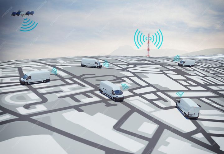
At its core, GPS tracking uses signals from satellites orbiting the Earth. A GPS receiver installed in a vehicle communicates with these satellites to determine its exact coordinates. These coordinates are then transmitted through a network connection to a digital platform where users can view vehicle routes, speed, and location history.
Originally developed for military navigation, satellite-based positioning gradually expanded into civilian uses. Today, GPS tracking is widely used across transportation, logistics, fleet management, emergency response, and personal mobility systems.
In practical terms, GPS tracking systems usually consist of three components:
| Component | Description |
|---|---|
| GPS Receiver | Collects signals from satellites to determine geographic position |
| Data Communication Module | Sends location data through cellular or satellite networks |
| Monitoring Platform | Displays maps, routes, and vehicle data through dashboards |
Many platforms also integrate mapping technologies and geographic information systems (GIS). These systems allow users to visualize routes, analyze travel patterns, and identify operational trends.
How GPS Tracking Works
The global positioning system relies on a network of satellites constantly transmitting signals to Earth. When a vehicle's GPS device receives signals from multiple satellites, it calculates its precise location using triangulation.
The basic process works like this:
| Step | Process |
|---|---|
| Satellite Signal Reception | Vehicle device receives signals from multiple satellites |
| Position Calculation | Coordinates are calculated using satellite timing data |
| Data Transmission | Location data is transmitted to a monitoring platform |
| Visualization | Maps and dashboards display vehicle movement |
Modern GPS tracking systems also combine technologies such as cellular connectivity, cloud computing, and analytics to provide detailed vehicle information.
Importance of GPS Vehicle Tracking
Vehicle tracking technology has become increasingly important as transportation networks grow more complex. Organizations and individuals rely on accurate location data to coordinate movement, improve operational visibility, and maintain safety standards.
One major reason GPS tracking matters today is the expansion of logistics and delivery networks. With global supply chains operating across long distances, location visibility helps stakeholders understand where vehicles are and how routes are performing.
Another important factor is road safety and driver accountability. Monitoring vehicle movement can highlight risky driving behavior such as sudden acceleration, harsh braking, or excessive speed.
Key Benefits and Impacts
| Area | Impact |
|---|---|
| Transportation Efficiency | Helps identify route patterns and travel time trends |
| Safety Awareness | Supports monitoring of driving behavior |
| Logistics Visibility | Enables real-time location awareness |
| Data-Driven Planning | Provides historical travel insights |
GPS vehicle tracking also helps transportation planners analyze traffic patterns and route congestion. When location data is collected over time, it can reveal important insights about road usage and travel behavior.
For businesses operating fleets, tracking systems contribute to improved coordination between drivers, dispatch teams, and operational managers.
At the individual level, GPS technology is widely used for navigation, roadside assistance coordination, and vehicle recovery support.
Recent Updates and Trends
Over the past year, several developments have influenced how GPS vehicle tracking systems are designed and used.
One notable trend during 2024–2025 has been the integration of artificial intelligence and predictive analytics into tracking platforms. Instead of simply displaying location data, newer systems analyze driving patterns and generate insights about route performance and vehicle usage.
Another development is the growing use of Internet of Things (IoT) devices in transportation monitoring. Modern tracking devices often collect additional information such as engine diagnostics, fuel consumption patterns, and environmental conditions.
Key Trends in GPS Tracking Technology
| Trend | Description |
|---|---|
| AI-Driven Analytics | Systems analyze driving patterns and route performance |
| IoT Integration | Devices gather additional vehicle and sensor data |
| Cloud-Based Platforms | Data is processed and accessed through cloud dashboards |
| Enhanced Mapping | High-resolution mapping improves location accuracy |
During 2025, many transportation technology companies also expanded the use of edge computing in tracking devices. Edge computing allows certain calculations to occur directly on the device instead of relying entirely on cloud servers.
Another trend is the use of 5G connectivity, which improves data transmission speed and enables faster updates between vehicles and monitoring platforms.
These developments reflect the broader digital transformation occurring within transportation and mobility systems worldwide.
Laws and Policies Related to GPS Tracking
GPS vehicle tracking is influenced by legal frameworks related to privacy, telecommunications, and transportation safety. Different countries regulate how tracking data can be collected, stored, and used.
In India, the government introduced regulations requiring vehicle tracking devices in certain categories of commercial vehicles under the Automotive Industry Standard AIS-140.
AIS-140 Vehicle Tracking Regulation
| Requirement | Purpose |
|---|---|
| GPS Tracking Device | Enables location monitoring for safety and emergency response |
| Panic Button | Allows passengers to send emergency alerts |
| Connectivity with Control Centers | Supports real-time monitoring for transport authorities |
AIS-140 standards are primarily applied to public transportation vehicles such as buses and taxis. The regulation was introduced to improve passenger safety and enable faster response during emergencies.
Another relevant policy area involves data privacy and digital governance. Tracking platforms that store location data must follow data protection guidelines to ensure responsible handling of sensitive information.
Governments across multiple regions are also exploring smart mobility initiatives, where GPS data contributes to traffic analysis, road planning, and urban transportation improvements.
Tools and Resources for GPS Vehicle Tracking
Several digital tools and platforms support vehicle location monitoring, route analysis, and navigation. These tools vary in complexity, ranging from simple mapping applications to advanced fleet management systems.
Common GPS Tracking Platforms
| Tool | Type | Purpose |
|---|---|---|
| Google Maps | Navigation App | Provides route guidance and location mapping |
| Waze | Navigation App | Displays traffic updates and route suggestions |
| Samsara | Fleet Platform | Provides vehicle monitoring dashboards |
| Geotab | Telematics Software | Collects vehicle data and analytics |
Navigation applications are commonly used by individual drivers for route planning and traffic updates. These apps rely on GPS positioning combined with mapping databases.
Fleet monitoring platforms provide more advanced capabilities, including dashboards that display multiple vehicles on a map simultaneously. These platforms often include analytics tools that examine historical travel data.
Useful Digital Resources
| Resource Type | Example Use |
|---|---|
| Mapping APIs | Integrate maps into software platforms |
| Telematics Dashboards | Analyze vehicle activity and travel patterns |
| Route Planning Tools | Identify optimal travel paths |
| Data Analytics Platforms | Interpret location data trends |
Developers also use mapping APIs and geolocation tools to build transportation applications, logistics software, and location-aware services.
Frequently Asked Questions
What is the main purpose of GPS vehicle tracking?
GPS vehicle tracking helps determine the geographic location of a vehicle using satellite signals. The information can be displayed on digital maps to monitor routes, travel patterns, and movement history.
How accurate is GPS vehicle tracking?
Under normal conditions, GPS location accuracy typically ranges between 3 to 10 meters. Accuracy may vary depending on signal strength, satellite visibility, and surrounding buildings or terrain.
What types of vehicles use GPS tracking?
GPS tracking is used in many transportation contexts, including commercial fleets, delivery vehicles, public transport systems, emergency response vehicles, and personal cars.
Does GPS tracking require internet connectivity?
The GPS receiver itself works through satellite signals and does not require internet access to determine location. However, transmitting location data to a monitoring platform usually requires cellular or satellite connectivity.
Is vehicle tracking regulated by law?
Yes, regulations in many countries govern how tracking systems can be used. These rules often address passenger safety requirements, device standards, and privacy considerations related to location data.
Conclusion
GPS vehicle tracking has become an essential component of modern transportation systems. By combining satellite positioning with digital communication networks, tracking platforms provide valuable information about vehicle location and movement.
The technology supports multiple applications, including logistics visibility, safety monitoring, route planning, and transportation analytics. As mobility systems continue to evolve, GPS tracking is increasingly integrated with emerging technologies such as artificial intelligence, IoT sensors, and cloud-based data platforms.
Recent technological developments during 2024 and 2025 highlight the growing importance of data-driven mobility solutions. Improvements in connectivity, analytics, and mapping technologies continue to enhance how location information is collected and interpreted.
Understanding how GPS tracking works, its regulatory environment, and the tools available for monitoring vehicle movement helps individuals and organizations make informed decisions about transportation technologies.
As urban mobility expands and digital infrastructure grows, GPS tracking will likely remain a foundational technology for navigation, logistics coordination, and transportation analysis in the years ahead.